Manitoba Métis Federation — 2022-12-16This dataset consists of data and supplemental materials related to the weather station located in St. Laurent, MB on the eastern shore of Lake Manitoba. The data file contains the downloaded curated weather file accessed from the Data Garrison site. The dataset is curated and added here as archived data. Additional information includes images of the weather station, a link to the data dashboards showing near real-time weather data, and instrument, deployment, publication and platform information.
This weather station replaces St Laurent Li Taan Aen Staansyoon_13390 and is currently collecting weather data from the same area. The station was deployed in August 2022.
Centre for Earth Observation Science — 2022-04-18Temperature and conductivity data collected from a thermosalinograph (TSG) on the William Kennedy platform. Salinity, density, and a variety of other variables can be derived from the raw temperature and conductivity data.
Centre for Earth Observation Science — 2024-03-21Autonomous CTD data from the 2023 Southern Hudson Bay - James Bay Expedition of the RV William Kennedy.
Centre for Earth Observation Science — 2022-02-25Hydrographic profiles using conductivity, temperature and depth (CTD) sondes were obtained across straits and along channels to best cover water column structure around the island. Two separate, but identical pumped Seabird 19plus CTDs with Biospherical scalar photosynthetically active radiation (PAR) and Seabird ECOtriplet fluorometer sensors, were used to collect hydrographic profiles, one standalone (autonomous) CTD and one mounted on the ship’s rosette. It is noted that the ship’s rosette also had a Seabird dissolved oxygen sensor. There were more than 200 profiles collected in total with very good coverage around the island.
Raw data and configuration files can be provided upon request by Janine Hunt (Data Curator).
Centre for Earth Observation Science — 2021-11-06Physical ice sampling data collected during the BaySys 2017 Churchill River and Mobile Ice Survey, the 2017 Nelson Estuary Landfast Ice Survey and the 2018 Hudson Bay Amundsen Campaign
Ice cores were collected using the 9 cm Mark II Kovacs core barrel in conjunction with teams 1, 3, and 4 from 2 mobile ice floes. Cores were bagged in core bags, labeled in the field, and transferred to CNSC. Coreswere cut with a metal Japanese saw into 5 cm portions outside of the CNSC main building (ambient temperature < -20 °C) in order to prevent thawing. All edges of each core section were then trimmed with ceramic knives to remove ice that came into contact with the core barrel or the metal saw. Trimmed sections were double bagged in new Ziploc bags and kept at room temperature in order to melt.
Delta Marsh Field Station — 2022-06-23A collection of photographs pertaining to the Delta Marsh Field Station and its activities.
Each year, the Delta Marsh Field Station sponsored a photo contest to document activities and places in and around the area. These were entries to the last one before the station closed.
Lake Winnipeg Research Consortium Inc. — 2022-04-07Data collected in 2008 during the spring, summer and fall cruises aboard the M/V NAMAO.
Data collected using a shipboard Seabird water quality profiler and four
channel profiling sonde (“Seabird rosette”).
Includes depth-averaged profiles in 0.5 m increments. Dataset also includes mapped profiles of Seabird parameters measured at respective sampling stations as well as Matlab scripts that produced the profiles (CSVs).
Lake Winnipeg Research Consortium Inc. — 2022-04-07Data collected in 2021 during the fall cruise aboard the M/V NAMAO.
Data collected using a shipboard Seabird water quality profiler and four-channel profiling sonde (“Seabird rosette”).
Includes depth-averaged profiles in 0.5 m increments. Dataset also includes mapped profiles of Seabird parameters measured at respective sampling stations as well as Matlab scripts that produced each profile (CSVs).
Centre for Earth Observation Science — 2021-11-09This dataset comprises a series of CSV files, each of which catalogues a suite of information for an individual cyclone track for the Northern Hemisphere. Detection and tracking are conducted using version 13.2 of the Lagrangian cyclone detection and tracking algorithm described by Crawford et al. (2021). This algorithm is applied to sea-level pressure data from Version 5 of the European Centre for Medium-Range Weather Forecasts (ECMWF) Retrospective Analysis (ERA-5) at a 3-hour temporal resolution and 25-km spatial resolution for the period 1950 – present (updated annually). Each CSV file contains information regarding the location, propagation, intensity, and size of the storm for each observation time. Whether a storm is a multi-center cyclone or interacting (splitting or merging) with other storm systems is also noted. Only cyclones that last at least 24 hours and travel at least 1000 km are included. These standard criteria are necessary to remove spurious systems (i.e., reduce the false positive rate).
Centre for Earth Observation Science — 2022-03-11This dataset includes calculated regional averages of surface and optical properties of mobile sea ice floes in the area of the stations sampled during the BaySys cruise in Hudson Bay in June/ July 2018.
Lake Winnipeg Foundation — 2022-03-02Two different surveying strategies provided insight into the wildlife and vegetation communities within the south basin of Lake Winnipeg. Incidental wildlife observations were conducted along the entire shoreline between Riverton and Traverse Bay from July 30 to August 4, 2011. Surveys were conducted from a boat operated approximately 30-metres offshore. All wildlife observed between the boat and the shoreline (littoral zone), or within a 30-metre buffer upslope of the high water mark (riparian zone), are included in the data. These sightings provided valuable insight into habitat use and preference of avian communities within the south basin. A second round of more intensive wildlife and vegetation sampling occurred in the south basin between August 4 and 7, 2011. Wildlife and vegetation surveys were conducted both off and on-shore at 23 locations in the south basin (shown on map).
Environment and Climate Change Canada — 2022-03-29Benthos data (Kick netting and Ekman dredge) from lake sampling locations across the littoral zone of Lake Winnipeg.
Centre for Earth Observation Science — 2022-11-03This dataset contains CTDs (salinity, temperature, pressure) and mooring data (salinity, temperature, pressure, TDS) at a number of depths and areas around the Belcher Islands from 2019-2022. Moorings were ice tethered and collected data continuously throughout the spring until ice break up in May. Moorings used a sampling interval of 15 minutes.
Centre for Earth Observation Science — 2022-10-04This study measures net ecosystem production, gross primary production, and gross respiration across Lake Winnipeg using an automated, custom-built incubator onboard the Motor Vessel (M/V) NAMAO.
Centre for Earth Observation Science — 2022-02-25Hydrographic profiles using conductivity, temperature and depth (CTD) sondes were obtained
across straits and along channels to best cover water column structure around the island. Two
separate, but identical pumped Seabird 19plus CTDs with Biospherical scalar photosynthetically
active radiation (PAR) and Seabird ECOtriplet fluorometer sensors, were used to collect
hydrographic profiles, one standalone (autonomous) CTD and one mounted on the ship’s rosette. It
is noted that the ship’s rosette also had a Seabird dissolved oxygen sensor. There were more than 200 profiles collected in total with very good coverage around the island.
Rosette data was collected using a Seabird 32 pylon, 19Plus V2, and 33 deck unit. Rosettes are water sampling instruments used in conjunction with oceanographic sensors to measure a number of variables. Rosettes give us a detailed snapshot of the entire water column through these sensors and through water samples collected at various depths within the column.
Raw data and configuration files can be provided upon request by Janine Hunt (Data Curator).
Lake Winnipeg Research Consortium Inc. — 2024-10-07Data collected in 2022 during the spring, summer, and fall cruises aboard the M/V NAMAO.
Data collected using a shipboard Seabird water quality profiler and four-channel profiling sonde (“Seabird rosette”).
Dataset also includes mapped profiles of Seabird parameters measured at respective sampling stations, as well as Matlab scripts that produced each profile (CSVs).
<br><br>
**Check out some results!**
<br>
This image shows photosynthetically Active Radiation (PAR) measurements across Lake Winnipeg during spring 2022.
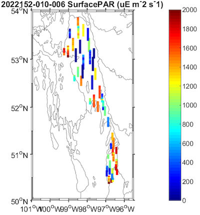
<br><br>
📸 Quickly view more images under **Supplemental** below, or download all images in the **Mapped** zipped folders.
Lake Winnipeg Research Consortium Inc. — 2024-10-08Data collected in 2023 during the fall cruise aboard the M/V NAMAO. Data collected using a shipboard Seabird water quality profiler and four-channel profiling sonde (“Seabird rosette”). Dataset also includes mapped profiles of Seabird parameters measured at respective sampling stations, as well as Matlab scripts that produced each profile (CSVs).
<br><br>
**Check out some results!**
<br>
This image shows photosynthetically Active Radiation (PAR) measurements across Lake Winnipeg during fall 2023.
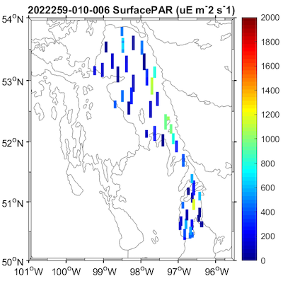
<br><br>
📸 Quickly view more images under **Supplemental** below, or download all images in the **Mapped** zipped folder.
Lake Winnipeg Research Consortium Inc. — 2022-04-07Data collected in 2009 during the spring, summer and fall cruises aboard the M/V NAMAO.
Data collected using a shipboard Seabird water quality profiler and four
channel profiling sonde (“Seabird rosette”).
Includes depth-averaged profiles in 0.5 m increments. Dataset also includes mapped profiles of Seabird parameters measured at respective sampling stations as well as Matlab scripts that produced the profiles (CSVs).
Lake Winnipeg Research Consortium Inc. — 2022-04-07Data collected in 2011 during the spring, summer and fall cruises aboard the M/V NAMAO.
Data collected using a shipboard Seabird water quality profiler and four
channel profiling sonde (“Seabird rosette”).
Includes depth-averaged profiles in 0.5 m increments. Dataset also includes mapped profiles of Seabird parameters measured at respective sampling stations as well as Matlab scripts that produced the profiles (CSVs).
(source : Canadian Watershed Information Network (CanWIN))
